
Adventure in South Georgia
King penguins in the snow, Fortuna Bay, South Georgia Island, Southern Ocean. Canon 1Dx, Canon EF 24-70mm/f4 MkII, 50mm, 1/640s at f14, ISO 500, handheld.
It's been already three years ago since I visited South Georgia for the first time. The islands are by far one of the most beautiful wildlife sanctuaries in the world, and the scenery with rough rugged mountain peaks is absolutely stunning. When my friend and photographer Onne Van der Wal told me about his expedition to the islands on a private sailing yacht years ago, I was so mesmerized that I had to see it for myself. It ended up on my bucket list, and I made the commitment to visit in 2012. That expedition made a lasting impression on me as I was blown away by the sheer number of penguins, seals and other wildlife that congregates on the islands to breed. A full report on my first South Georgia experience and a lot of history about the islands can be found here: South Georgia and The Falkland Islands 2012
Although I was really happy with the images that I had taken during my first visit, I felt I had missed some important parts of the story. In a place like South Georgia there is never an end to the photographic opportunities. You could easily spend a lifetime on the island and never take the same image. It is virtually impossible to capture the beauty of the place in just 9 days. For all of us that photograph nature, we know that the circumstances are never the same. Weather changes constantly, wildlife can be abundant, but at other times non existing, and seasons drive activity. There are a lot of moving parts which make it hard to tell a complete story with just one visit. That is why I like to go back to the same location multiple times, and preferably at different times throughout the year. This increases your changes for variety and different images.
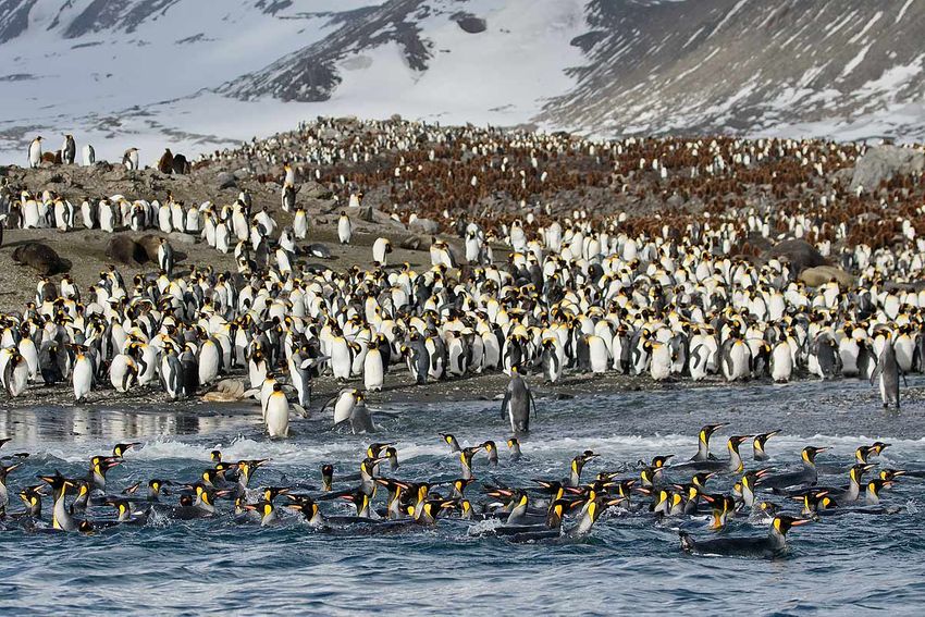
King penguins swimming in front of beach, St. Andrews Bay, South Georgia Island, Southern Ocean. Canon 7D MkII, Canon EF 100-400mm/f4-5.6 MkII, 124mm, 1/3200s at f6.3, ISO 400, handheld.


Then there is the time and cost aspect of it all. Usually, the expeditions to faraway places are time consuming and costly. A typical expedition to the Falklands, South Georgia and the Antarctic Peninsula will take 30 days plus travel at a rate of close to $1,000 per day. This is a tough nut to crack if you have a serious day job, and not reached retirement yet. I was really pleased that Ted Cheeseman (www.cheesemans.com) was able to put an expedition together with maximum time ashore in South Georgia and a total expedition time of 14 days. Once he announced the trip, I signed up immediately and contacted my friend Paul McKenzie from Hong Kong, with whom I shared a cabin on the first expedition. Paul has the same philosophy as me, and wanted to go back as well. We were both happy and looking forward to another great experience in October 2015. Unfortunately, on the day of my departure, Paul e-mailed me that he had to cancel due to an unfortunate medical issue. In a remote and uninhabitat location as South Georgia the nearest hospital is at least three days away in the Falkland Islands. If you have a medical emergency, you are pretty much on your own as the medical support on board of the vessel is very basic. I spoke to Paul, who was obviously extremely disappointed, but assured him that he made the right decision not to put his life in jeopardy. South Georgia will still be there. Fortunately, Paul will be going to South Georgia next year.
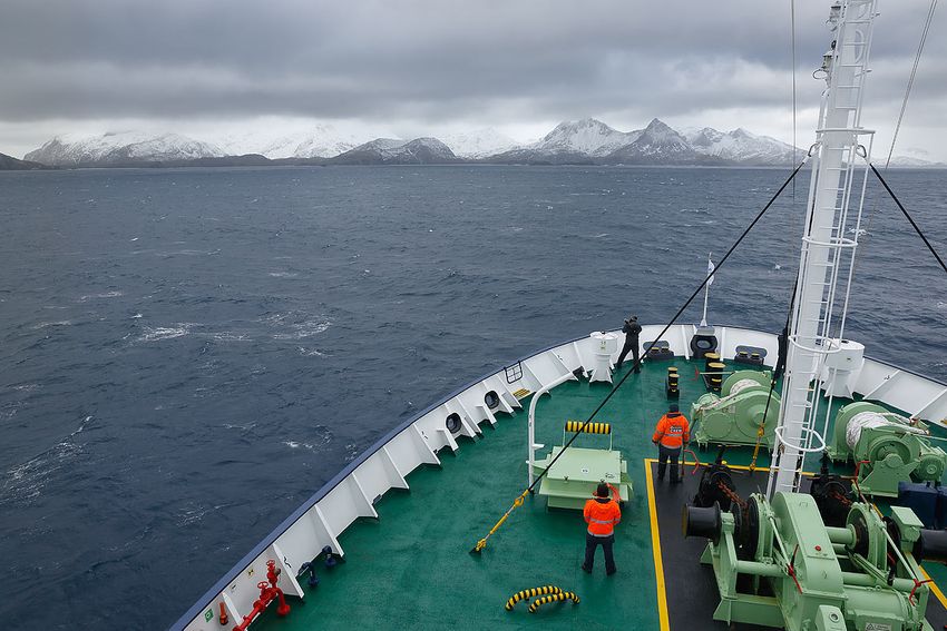
MV Ortelius approaching South Georgia, South Georgia Island, Southern Ocean. Canon 5D MkIII, Canon EF 24-70mm/f4 MkII, 24mm, 1/200s at f9, ISO 200, handheld.
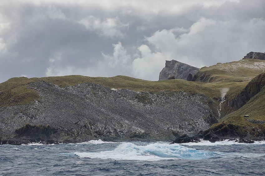
Macaroni penguin colony “Big Mac”, Bird Island, South Georgia Island, Southern Ocean. Canon 5D MkIII, Canon EF 100-400mm/f4-5.6 MkII, 234mm, 1/1000s at f8, ISO 200, handheld.
My main focus has always been wildlife since I took up photography in a serious way early 2010. I love taking nice portraits and close-ups of birds and other animals. It is actually incredible what you see if you look through a long lens. You see details you would never see with bare eyes. It took me a couple of years to widen my view and also look at the animals in their environment, or even the landscape alone for that matter. Often times, you are so focused on the subject that you forget to look around and take in what else is there. I felt I made that mistake on my previous expedition to South Georgia, and missed the opportunity to document the beauty of the islands itself with their stunning scenery and large ice covered mountain peaks. For people who have not been to South Georgia, the best way to explain what to expect is to imagine that the Swiss Alps are cut out with a large knife, and dumped in the middle of the Southern Ocean. A magnificent alpine landscape with broad rivers of ice flowing to the sea. This time I deliberately took a wider view on South Georgia.
We boarded our vessel on Saturday afternoon in Port Stanley, Falkland Islands, and headed out in a gale force 10 with 30 feet seas on our way to South Georgia. We reached the islands in the late afternoon of the third day at sea. It is always an exciting experience to spot the first land emerging out of the clouds through the binoculars. On our way to the south west side of the island we spotted a large tabular iceberg stranded in the shallow coastal waters around the island. The size of the iceberg must have been over a mile long and easily 100 feet tall. This iceberg made it's way up from Antarctica, where it most likely broke loose from one of the disintegrating ice shelfs. When we made our way around the island during the next days we spotted an abundance of stranded icebergs, which was substantially more than we saw during the 2012 expedition. I am inclined to say this is the direct result of our changing climate. These icebergs will eventually melt and contribute to a rising sea level in the years to come.
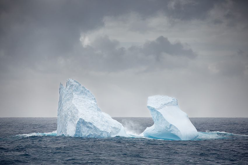
Iceberg floating of Bird Island, South Georgia Island, Southern Ocean. Canon 5D MkIII, Canon EF 100-400mm/f4-5.6 MkII, 400mm, 1/1600s at f5.6, ISO 320, handheld.
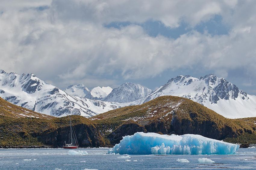
Iceberg and sailing yacht, Maiviken, South Georgia Island, Southern Ocean. Canon 7D MkII, Canon EF 100-400mm/f4-5.6 MkII, 158mm, 1/800s at f6.3, ISO 200, handheld.


With the weather as main variable during those expeditions, no fixed plan ever comes to fruition. All the landings are weather dependent and alternatives have to be assessed on a daily basis. It is great teamwork between the expedition staff and the ship's crew to maximize the opportunities and be flexible with planning. Upon arrival the weather was still rough but we made our first late afternoon landing in Undine Harbor. The next day we relocated to King Haakon Bay to drop off a group of trekkers at Peggotty Bluff, who were going to cross the island in the footsteps of Sir Ernest Shackleton. Unfortunately, the weather was still not cooperating and the landing was called off. On our way around the north west side of the island we passed by the tabular iceberg and Bird Island before anchoring at the entrance of Elsehul bay.


Elsehul is one of the last breeding places for the endangered Grey-headed Albatross. Together with the Light-mantled Sooty Albatross they nest on the cliffs around the bay. The terrain in Elsehul is typical for the island. Large amounts of tussock grass fill the sloping hills and the cliffs. Walking across the tussock grass landscape is a difficult task and can be dangerous and slippery at times. It took me more than an hour to walk up and around the bay to get to photograph the nesting Grey-headed Albatrosses, without breaking a leg or my camera gear.
Cumberland Bay
The next day we entered Cumberland Bay, one of the larger bays on the island. Many glaciers end up in the waters of Cumberland Bay, such as the large Neumayer Glacier and the Lyell Glacier. I have always been fascinated by the glacier fronts with their shades of blue, deep crevasses and textures. The ancient compacted, and oxygen deprived ice creates deep shades of blue that contrast nicely with the fresh white snow and moraine debris that makes glaciers living vanes. Unfortunately, even in South Georgia the glaciers are residing at high speed and will disappear quicker that we all expect.
View of interior mountains at Thatcher Peninsula , Grytviken, South Georgia Island, Southern Ocean. Canon 5D MkIII, Canon EF 24-70mm/f2.8 MkII, 60mm, 1/640s at f14, ISO 200, handheld.

At the entrance of Cumberland Bay we landed in a little bay called Maiviken. From here we made the trek across the mountain pass towards the old whaling base of Grytviken. Grytviken is home to a British research station, and the only place on the island where humans live on a permanent basis. It is also the official seat of the South Georgia Government, and every ship has the obligation to clear customs in Grytviken. This is a welcome distraction for the local British staff who otherwise would be deprived of human contact for a long time.


The hike to Grytviken was pretty strenuous, especially with a backpack full of camera gear, but the views were absolutely incredible. The interior of South Georgia is full of snow covered mountain peaks as far as the eye takes you. Walking down the last pass into the old abandoned whaling station of Grytviken brought back memories of the heroic last part of Shackleton's adventure when he stumbled totally exhausted into the whaling station of Stromness.
We continued our voyage to the north eastern side of the island and landed in Cooper Bay in the morning. In 2012 this was a landing with heavy snow fall and a demanding climb up the hill through snow covered tussock grass. This time we had a beautiful morning with sunlight peaking through the clouds. A thick pack of snow made walking up the tussock grass covered hill relatively easy. Cooper Bay has a large colony of Macaroni penguins, and there is no greater treat than photographing them in the snow. The toughest job is to get a nice clean white background, which make the Macaroni penguins stand out beautifully, but that is easier said than done, as they tend to hide behind or under the tussocks.


After lifting anchor we sailed through the Cooper Sound towards Drygalski fjord. Quite a lot of icebergs had gathered on this side of the island, some of them with Chinstrap penguins on them. The coastline on this side of the island is scattered with sharp mountain peaks and large glaciers. The rough landscape reminded me of the black and white images that Frank Hurley took on Shackleton's expedition to the south pole. He started off with photographing some mountain vistas overlooking Leith Harbour and the whaling station of Stormness before they set sail on their Endurance expedition to Antarctica in 1914. Black and white really emphasizes the character of the landscape and makes the image so much more impactful.

When we turned into Drygalski fjord the weather started to change, the wind picked up and heavy clouds rolled in from the Risting glacier at the end of the fjord. Passing through the fjord can be really scenic but you need some visibility to show the steep ice-covered mountain faces. With further deteriorating conditions we did not make it to the end and turned around for a peak into Larsen Harbour, a sheltered side arm of the fjord.

The following morning we landed at Gold Harbour, under challenging conditions with high winds and snow flurries. On the way back to the ship the wind had picked up even further making the zodiac operations pretty challenging for the crew. An afternoon landing was planned for St. Andrews Bay, one of the most spectacular wildlife sites on the island. St. Andrews Bay is a very exposed bay, and with the wind and ocean swell from the wrong direction, landing on the beach is risky. Unfortunately, a landing at St. Andrews Bay was not in the cards for that afternoon, instead we went to Godthul, a protected and sheltered bay.
We continued our voyage during the night along the north side of the island in westerly direction to visit Fortuna Bay. The chances of photographing King penguins in the snow around this time of the year are the largest at Fortuna Bay and Right Whale Bay, both fairly flat areas surrounded by mountains on each side. The density of the penguins was less than my previous experience, but that in itself does not have to be alarming, as the penguins return to shore to molt and breed over a period of time in the early spring season. One or two weeks later could make a big difference in the number of birds present in the colonies. Later in the day we sailed east again to make a quick stop in the abandoned whaling station of Stromness. I was working on my images in the bar when I peaked out of the window and noticed some color in the corner of my eye. Curious, I stepped outside and to my surprise saw an incredible rainbow right in front of the ship. I quickly ran downstairs to my cabin and grabbed my camera, got back up on the front deck, and realized I forgot my polarizer. Ran down again to get it in the hope that the rainbow would still be there. To my surprise nobody had noticed the rainbow, and I was the only one who documented this phenomena. Later, I asked the ship's crew if they had seen such a rainbow before, but also for them it was a novelty.


The next morning we anchored at St. Andrews Bay for a second attempt to make a landing. This time the weather was in our favor with calm seas and a beautiful sunrise. We landed at 4:30am with gorgeous light on the beach and the mountains in the background. This time I had the opportunity to photograph the wildlife spectacle with tons of King penguins and Elephant seals on the beach from the water, which gives a completely different and unique perspective, especially in the soft early morning light. When the morning progressed, the light started to become harsh. Luckily the clouds moved in, and the rest of the day we worked with a heavy overcast sky. With plenty of ground to cover, no shortage of subjects to photograph and cooperating weather, this landing became the longest and most spectacular landing of the expedition. Completely exhausted, and not able to lift my camera anymore, I finally went back to the ship on one of the last zodiacs around 5pm in the afternoon. Twelve hours of amazing photography and about 2700 images that day, which is quiet amazing, as I am usually pretty conservative with pressing the shutter button.


On our final day in South Georgia we had one more great landing site to visit. Salisbury Plain in the Bay of Isles is number two in rank after St. Andrews Bay, with also an abundance of King penguins lined up along the shore line and across the colony towards the mountains. Yet another early rise to a beautiful morning with sun peaking through the scattered clouds. After working the beach and venturing off to a large snow patch with King penguins, I wanted to get up high for an overview of the colony and the Bay of Isles. With a small group we walked towards the Lucas Glacier and hiked up a steep mountain ridge to get to up to altitude, and transversed over a snow covered ridge towards a viewing point high above the colony. The view across the Bay of Isles was pretty spectacular, and I finally got myself to sit down and just appreciate what I was looking at; a peaceful world in perfect balance, unspoiled by human intervention. This is what it has always been, and will be for a long time to come. I hope.
With the weather forecast deteriorating we made one last stop at Prion Island, before heading back to sea for the three day ocean crossing to the Falkland Islands. With South Georgia slowly disappearing over the horizon, another great expedition came slowly to an end, leaving great memories and lots of images to look at.
-

Sunrise at Bay of Isles, Salisbury Plain, Bay of Isles, South Georgia Island, Southern Ocean. Canon 5D MkIII, Canon EF 70-200mm/f2.8 MkII, 70mm, 1/250s at f8, ISO 200, handheld.
The complete portfolio of my trip to South Georgia and more wildlife images can be viewed on my website at www.clemensvanderwerf.com
Please leave a comment if you like the story and images.