
While most of the US is hunkered down under a tremendous arctic freeze that has disrupted large parts of the country, with temperatures and wind chills well in the minus double digits, it seems already a long time ago since I made my recent trip to the southern most continent in the world. In November 2013 I traveled from Miami to Ushuaia in Argentina, to join ice-class expedition vessel Polar Pioneer for a two week expedition to the Antarctic Peninsula. This was my second visit to one of the most stunning and surreal places in the world. Having been to the Antarctic Peninsula in January last year, I wanted to see what it was like to go a couple of months earlier in the season. The January trip, which was during the summer in the southern hemisphere, had been amazing with lots of wildlife and gorgeous color in the sky. Various penguins species were caring for their just born chicks. Seals, whales and other cetaceans where plentiful due to the increase in food sources during the warmer months in the area. The trip in the beginning of November was in the early spring when the continent just woke up out of a brutal cold and dark winter. I wanted to see the difference in landscape and wildlife, which would obvious result in different images. Although the temperature on the Peninsula was around freezing and considered very mild compared to the Arctic Vortex in the US, we had plenty of snow and ice to deal with and the wind chill made it occasionally very cold.
Antarctica - Land of snow and ice
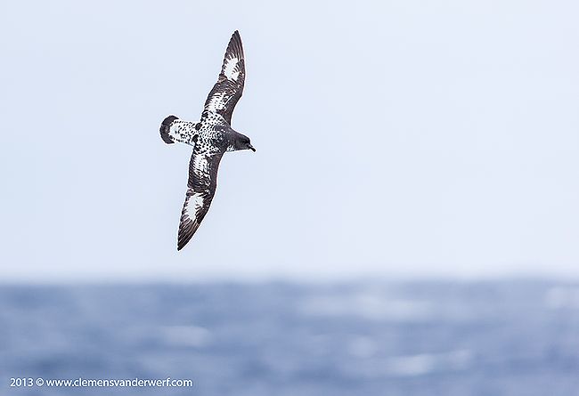
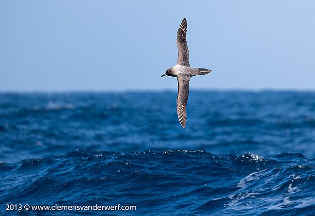
Cape Petrel banking in the Drake Passage. Canon EOS 1Dx, Canon EF 200-400mm f/4L IS USM Lens with Internal 1.4x Extender @ 519mm, f5.6, 1/1600s, ISO 800, Manual exposure, hand held. Image by Clemens Vanderwerf and copyright 2013
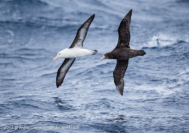
Southern Giant Petrel and Black Browed Albatross in the Drake Passage. Canon EOS 1Dx, Canon EF 200-400mm f/4L IS USM Lens with Internal 1.4x Extender @ 540 mm, f5.6, 1/1600s, ISO 800, Manual exposure, hand held. Image by Clemens Vanderwerf and copyright 2013
I arrived a day earlier in Ushuaia, just to have some margin in case of flight delays, as you do not want to miss the boat but Aerolinas Argentinas performed on time from Buenos Aires. I spent the afternoon with two friends and we took a taxi up the mountain to the local ski resort which was already closed for the season. We hiked up the slope until we reached the entrance to the glacier. All of a sudden the wind picked up and started hauling and blowing dry snow down the mountain. It was time to turn around and walk back to the base station, where we were fortunate enough to find a souvenir shop still open to buy a cup of hot chocolate and warm up again. I attended my friends to a framed picture of the Dutch King and his beautiful Argentinian wife Maxima that was proudly standing on the counter. It is funny to know the Argentinian people treat our royals also as partly theirs.
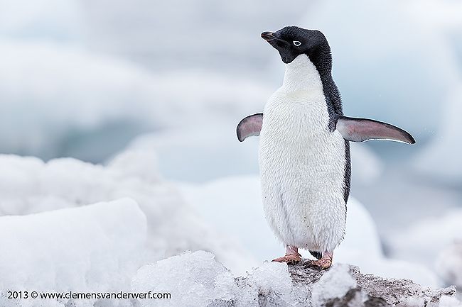
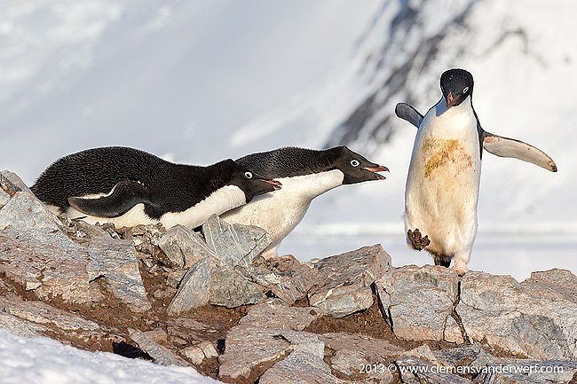
Adelie penguin stretching his wings at Arctowski Base. Canon EOS 1Dx, Canon EF 200-400mm f/4L IS USM Lens with Internal 1.4x Extender @ 334 mm, f5.0, 1/800s, ISO 500, Manual exposure, hand held. Image by Clemens Vanderwerf and copyright 2013
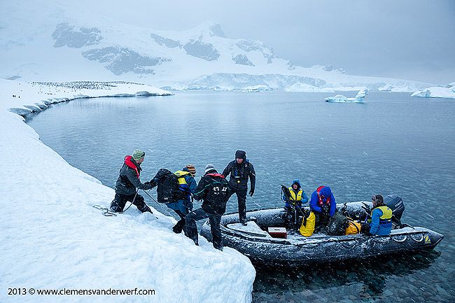
After some last minute shopping in the many local outfitter stores in Ushuaia (I found a great pair of waterproof gloves which still allows me to control all my camera buttons) we made our way to the port in the afternoon to meet up with the Polar Pioneer. The Polar Pioneer is an ex-Russian research vessel with a length of 72 meters, 23 crew and about 45 passengers. Not very large, but very well suited for Arctic and Antarctic exploration travels. After embarkation and settling into our cabins the expedition staff from Aurora Expeditions had to start with the familiarization program and introduce staff and daily routines. One important part from a safety perspective is always the lifeboat routine. Everybody had to retreat to their cabins, and upon the emergency signal from the bridge had to put on their life vest and gather outside on deck at the designated muster station. In this case we all had to enter the lifeboat as packed sardines and the crew had to close the door and start the engine. I do not even want to imagine how this would be in a real life situation with high waves throwing the boat all over the place. It is going to be very quickly, very hot and smelly.
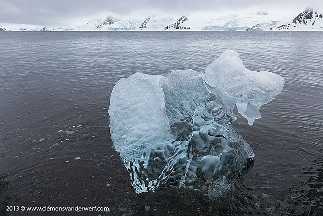
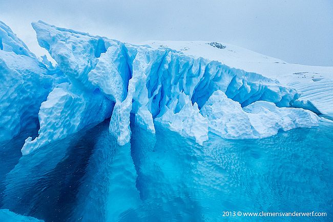
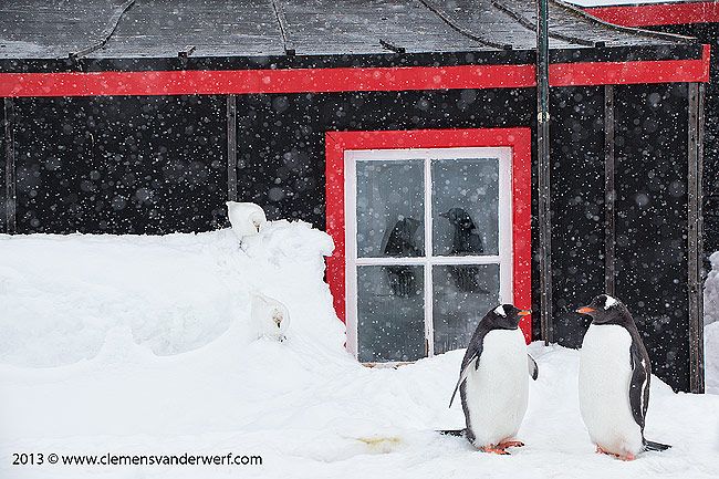
Ice sculpture on the beach at Arctowski Base. Canon EOS 1Dx, Canon EF 24-70mm f/2.8L MkII USM Lens @ 28mm, f13, 1/200s, ISO 500, Manual exposure, hand held. Image by Clemens Vanderwerf and copyright 2013
In order to reach the Antarctic Peninsula you have to leave the protected waters of the Beagle Channel which separates Argentina and Chile, and cross one of the most roughest seas on the planet, the Drake Passage. Often times 50-60 knots winds and similar wave heights will make the crossing really unpleasant, with the ship rolling and pitching for two and a half days at sea. The weather forecast was not looking that good for us either. After applying a Scopolamine patch behind my ear to prevent seasickness, we had a welcome toast and great first diner on board before we entered the "Drake-Shake". Under these circumstances it is really important that you keep one hand for yourself and one hand for the ship, otherwise you will be flying off the stairs and through the walkways. Even using the bathroom under those conditions becomes a real challenge. The safest place to be is in your bunk, which many people occupied not entirely voluntary during the crossing of the Drake. Luckily, it was not as bad as expected, and it allowed me to go on the back deck to photograph various birds flying behind the vessel hoping to find food in the propeller wash. Once in the middle of the Drake Passage the number of birds following the ship is decreasing rapidly due to the deep water and limited food availability in that part of the ocean. Once you get closer to land again, in this case the South Shetland Islands, the food source increases and the number of birds at the stern of the vessel becomes numerous again. Getting closer to the Peninsula also increases the chance of seeing the first ice bergs. A competition was held under the shipmates to guess the position coordinates of the first ice berg, which we did not see until we entered the Brandsfield Strait between the South Shetland Islands and the Peninsula.
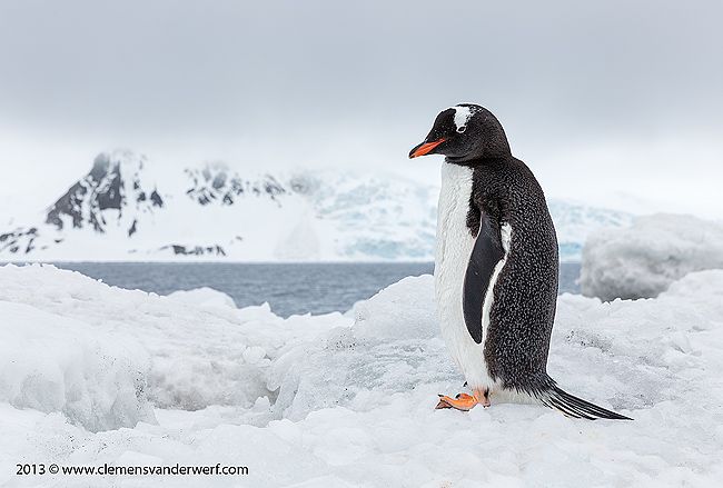
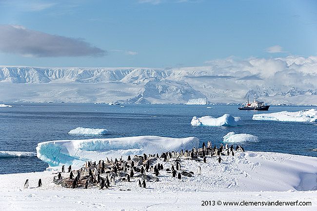
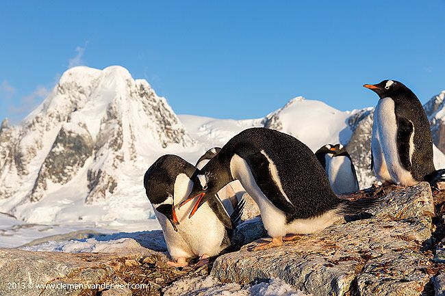
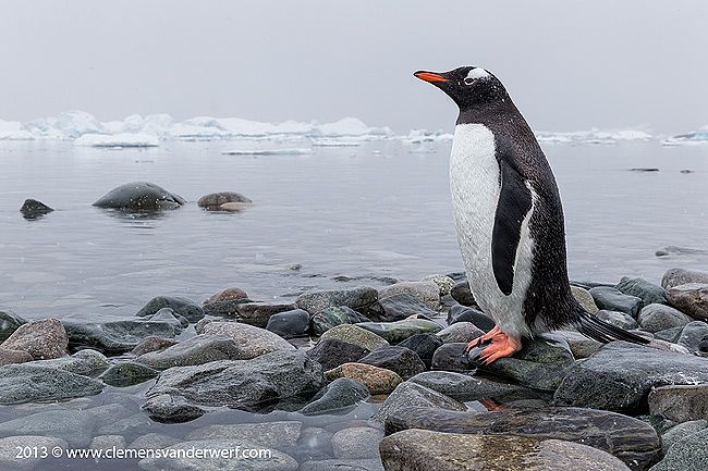
Gentoo penguin overlooking the bay at Arctowski Base. Canon EOS 1Dx, Canon EF 24-70mm f/2.8L MkII USM Lens @ 67mm, f10, 1/320s, ISO 640, Manual exposure, hand held. Image by Clemens Vanderwerf and copyright 2013
Our first stop in the South Shetland Islands was the Arctowski Polish Antarctic Station on King George Island. The station is named for Henryk Arctowski (1871-1958), who as meteorologist had accompanied the Belgian explorer Baron Adrien de Gerlache on the "Belgica" expedition, 1897-1899. This was the first expedition to overwinter in Antarctica. Arctowski proposed the original notion of a wind chill factor, arguing that wind could be as damaging to human flesh as cold in harsh climates. The main reason for the visit was to drop off two US scientists Dr. Wayne Trivelpiece and Penny Chilton, who would man scientific camp Copacabana about two miles from the Polish base to do research on the local penguin colonies at the island, an effort that is going on for the last 30 years.
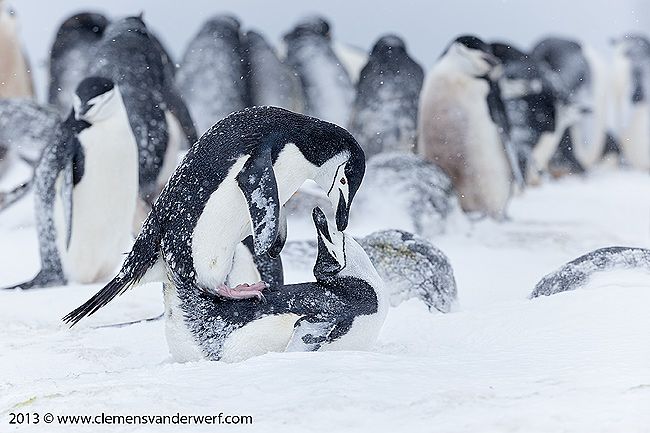
Chinstrap penguins copulating at Half Moon Island. Canon EOS 1Dx, Canon EF 200-400mm f/4L IS USM Lens with Internal 1.4x Extender @ 300 mm, f5.6, 1/800s, ISO 1000, Manual exposure, hand held. Image by Clemens Vanderwerf and copyright 2013
On board I had a discussion with Dr. Wayne Trivelpiece and he was explaining that Antarctic ecosystems face profound changes due to rapid climatic warming and expanding fishing efforts. Heavily affected is the Antarctic krill, tiny, shrimp-like crustaceans that serve as the key prey for many predators like penguins, seals, whales and seabirds. They are a main target of an expanding commercial fishery aimed in part at obtaining ingredients for aquaculture feeds. In many areas, the commercial fishery operates in the feeding grounds of breeding, krill-dependent predators, such as penguins. The Antarctic is among the fastest warming ecosystems on the planet, with 5–6 °C increases in mean winter air temperatures in the last few decades. This has a profound affect on sea-ice cover and is also a major driver of population shifts in krill predators, because some penguin species prefer extensive ice cover while others do not.
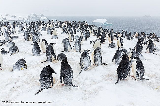
Chinstrap penguin colony at Half Moon Island. Canon 5D MkIII, Canon EF 24-70mm f/2.8L MkII USM Lens @ 24mm, f14, 1/400s, ISO 1250, Manual exposure, hand held. Image by Clemens Vanderwerf and copyright 2013
Dr. Wayne Trivelpiece was explaining that an estimated 150 million extra tons of krill might have been available to other krill predators, such as penguins, following intensive whaling in the 19th and early 20th century. Some studies show that Adélie and chinstrap penguin populations followed this change and increased between the 1930s and 1970s. Since then, however, climatic warming, a targeted krill fishery and recovering whale and fur seal populations have depressed krill abundance by almost 80 percent in the Southern Ocean. Accordingly, Dr. Trivelpiece’s study estimates that populations of both Adélie and chinstrap penguins have declined in the South Shetland Islands by more than 50 percent, and other studies have shown declines of up to 75 percent in nearby regions during this time. As warming continues, winter sea-ice will disappear from much of this region and exacerbate krill and penguin declines.
Chinstrap penguin pair on next at Half Moon Island. Canon EOS 1Dx, Canon EF 200-400mm f/4L IS USM Lens with Internal 1.4x Extender @ 280 mm, f5.6, 1/800s, ISO 800, Manual exposure, hand held. Image by Clemens Vanderwerf and copyright 2013
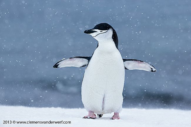
Chinstrap penguin with wings spread at Half Moon Island. Canon EOS 1Dx, Canon EF 200-400mm f/4L IS USM Lens with Internal 1.4x Extender @ 200 mm, f5.6, 1/800s, ISO 1000, Manual exposure, hand held. Image by Clemens Vanderwerf and copyright 2013
On an earlier trip to Antarctica with the penguin counters of Oceanites I learned that Adelie penguin numbers are declining rapidly and that Gentoo penguin numbers are actually increasing. Dr. Wayne Trivelpiece had a remarkable explanation for this phenomena. Apart from the reason as mentioned before, the decline in Adelie penguins is caused by the way they care for their offspring. Once the Adelie penguin chicks reach early maturity, the parents abandon their chicks and leave for the season. The chicks have to learn how to find their own food to reach adulthood. This is an increasingly difficult task as the main food source, Krill, is less numerous and harder to find for the younger penguins. Lots of young Adelie penguins die due to simple starvation, and not being able to care for themselves. The Gentoo penguins, however, care for their offspring longer, and learn them how and where to hunt for krill. The parents stay with the youngsters until they are able to sustain themselves before they set off on their own. A remarkable difference in survival skills. The Adelie penguins are unfortunately not able to change their behavior quick enough to deal with the rapidly changing circumstances in their environment.
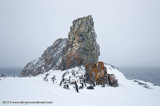
Chinstrap penguin colony and colored rocks with lichen at Half Moon Island. Canon 5D MkIII, Canon EF 24-70mm f/2.8L MkII USM Lens @ 24mm, f14, 1/100s, ISO 800, Manual exposure, hand held. Image by Clemens Vanderwerf and copyright 2013
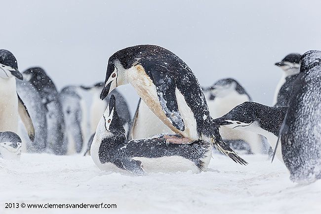
Chinstrap penguins copulating at Half Moon Island. Canon EOS 1Dx, Canon EF 200-400mm f/4L IS USM Lens with Internal 1.4x Extender @ 316 mm, f8, 1/800s, ISO 1000, Manual exposure, hand held. Image by Clemens Vanderwerf and copyright 2013
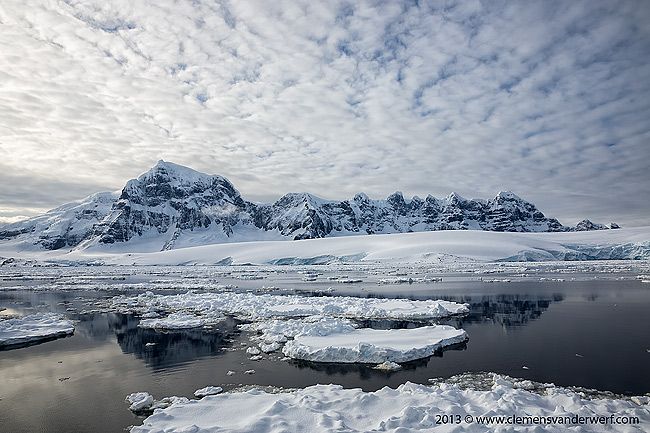
We left Arctowski Station before noon and made our way west along the South Shetland Islands to make a landing at Half Moon Island. Half Moon Island is home to a colony of Chinstrap penguins and some nicely colored rock outcroppings. We arrived with heavy overcast but good visibility, but once we landed it started snowing heavily and the wind picked up considerably, making it challenging conditions for photography. I had been here before and knew exactly where the best opportunities were to find penguins against clean backgrounds. Most people walked straight up the hill to the nearest colony of Chinstraps, but I took a left and went over the ridge to another colony that was out of sight. I pretty much had the colony to myself for a couple of hours. I had some good opportunities to visualize the harsh habitat the penguins live in. Most of them where hunkered down to protect themselves from the snow and heavy winds beating on their backs on the exposed hillside. When I circled back to the original colony closer to the landing area, most people had already gone back to the ship and allowed me to get some nice images with the colored rocks covered with lichen. The snow was really knee deep at most places and made it hard to move around in with a backpack full or camera gear. As usual I was on the last zodiac back to the ship.
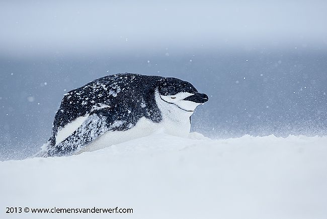
Chinstrap penguin hunkered down in snow storm at Half Moon Island. Canon EOS 1Dx, Canon EF 200-400mm f/4L IS USM Lens with Internal 1.4x Extender @ 400 mm, f5.6, 1/1000s, ISO 1000, Manual exposure, hand held. Image by Clemens Vanderwerf and copyright 2013
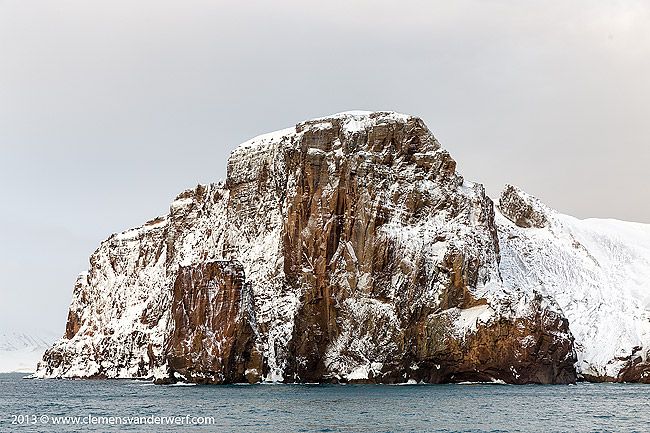
Rock formation at the entrance to Neptunes Bellows at Deception Island. Canon 5D MkIII, Canon EF 24-70mm f/2.8L MkII USM Lens @ 67mm, f8, 1/160s, ISO 400, Manual exposure, hand held. Image by Clemens Vanderwerf and copyright 2013
During the night we positioned for our next destination, Deception Island, an active volcano in the South Shetland Islands. Its unique landscape comprises barren volcanic slopes, steaming beaches and ash-layered glaciers. It has a distinctive horse-shoe shape with a large flooded caldera. This opens to the sea through a narrow channel at Neptunes Bellows, forming a natural sheltered harbour. It is one of the only places in the world where vessels can sail directly into the centre of a restless volcano. One of the largest Chinstrap penguin colonies can be found near Bailey Head on the south side of the Island. It is a difficult place to land due to the steep black volcanic sand beach that can become quite dangerous with heavy sea swell. I asked the expedition leader if we would make a landing there if the conditions would allow, but he bluntly said that no vessels ever land there because it is too dangerous. When we passed by Bailey Head in the early morning there was hardly any wind and swell, so it was quite a disappointment that the opportunity was not even investigated. On my last trip with Cheeseman's Ecology Safaris, every effort was made by expedition leader Hugh Rose, to put us ashore at Bailey Head, and we experienced one of the most amazing days of the expedition.
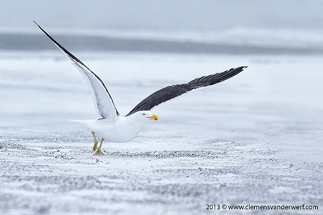
Kelp Gull flying away at Whalers Bay, Deception Island. Canon EOS 1Dx, Canon EF 70-200mm f/2.8L MkII IS USM Lens @ 185mm, f5.6, 1/1600s, ISO 1000, Manual exposure, hand held. Image by Clemens Vanderwerf and copyright 2013
We approached the entrance to Neptunes Bellows in gorgeous early morning light. The brown colored rocks of the volcano rim where dusted with white snow as we slowly entered the channel into the volcano. We anchored in Whalers Bay near the geothermal beach. Whalers Bay has been designated as historic site, and comprises all pre-1970 remains on the shore of the bay. These include artefacts and structural remains from the early whaling period (1906–1912) associated with Captain Adolfus Andresen of the Chilean Sociedad Ballenera de Magallanes, the Norwegian Hektor Whaling Station (1912–1931), the period of British scientific and mapping activity (1944–1969), and a cemetery containing 35 burials and a memorial to ten men lost at sea. It also commemorates and acknowledges the historic value of other events that occurred there.
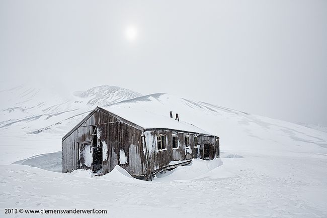
Old whalers hut in Whalers Bay at Deception Island. Canon 5D MkIII, Canon EF 24-70mm f/2.8L MkII USM Lens @ 24mm, f10, 1/800s, ISO 400, Manual exposure, hand held. Image by Clemens Vanderwerf and copyright 2013
The scenery was completely different from the last visit here in January. The recent snowfall had covered the beach and the old whaling station remains under a thick layer of snow. The old wooden houses and airplane hangar were filled with piles of snow, and the rusted barrels and equipment stuck out on the white canvas. While we landed with the zodiacs on the beach it started snowing and we made our way through the snow in near blizzard conditions. Many of the shipmates were really excited by the rusty old whaling artifacts covered in snow, but I felt no immediate connection with the industrial remains of prior generations. As I walked along the beach I spotted two Subantarctic Skuas who had decided the weather was too awful for any activity, and had hunkered down in the snow hoping for some future relief.
About a dozen Kelp Gulls and Antarctic Terns were hanging out between the rusty artifacts, and I took great care in approaching them by laying on my belly and slowly crawling forward through the snow to get within decent reach for my beloved camera combo, the Sigma 50-500mm lens and Canon 1Dx body. The Kelp Gulls were rather skittish and just when I had crawled within firing range they decided the fly up and land behind me in the snow. I had more luck with the Antarctic Terns who obviously had a nest up on one of the rusty vessels and were flying up frequently. It was nice to get a good flight image of an Antarctic tern as these little birds are extremely fast with erratic flight patterns.
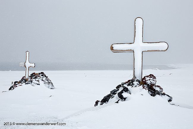
Graveyard in Whalers Bay at Deception Island. Canon 5D MkIII, Canon EF 24-70mm f/2.8L MkII USM Lens @ 61mm, f10, 1/500s, ISO 400, Manual exposure, hand held. Image by Clemens Vanderwerf and copyright 2013
After photographing the wildlife is was time for some of the old crippled buildings, the graveyard, rusty whale blubber vessels and wooden whaling boats that lay scattered over the snow covered area. From all these non wildlife items, the wooden whaling boats were by far my favorite and I spend some time creating pleasing compositions. After about 4 hours in the cold, snowy and windy weather it was time to go back to the ship for a warm cup of coffee. We left Deception Island at the end of the morning on our way to the next destination on the Antarctic Peninsula.
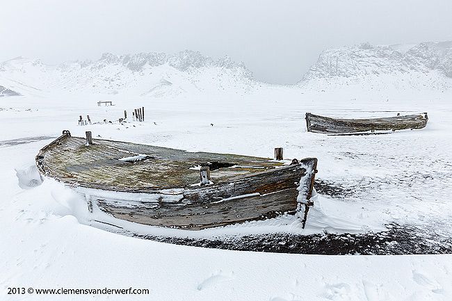
Old whaling boats on the beach in Whalers Bay at Deception Island. Canon 5D MkIII, Canon EF 24-70mm f/2.8L MkII USM Lens @ 24mm, f11, 1/400s, ISO 400, Manual exposure, hand held. Image by Clemens Vanderwerf and copyright 2013
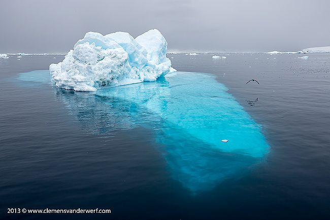
After crossing the Brandsfield Strait in southerly direction we entered the Gerlache Strait and arrived in Hughes Bay around dinner time. A late evening cruise was planned in Cierva Cove. The area is full of large icebergs against the backdrop of the Sikorsky glacier. As nearly all the photographers on board had a strong preference for landscape images, we cruised around in the zodiac looking for interestingly shaped icebergs and ice formations. The low blue light created an eerie atmosphere, until a small break in the clouds let through some last sunlight.
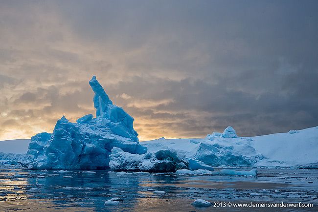
Blue iceberg in late evening light, Cierva Cove, Hughes Bay. Canon EOS 1Dx, Sigma 50-500mm f/5.6-6.3 IS Lens @ 70mm, f9, 1/400s, ISO 500, Manual exposure, hand held. Image by Clemens Vanderwerf and copyright 2013
Blue iceberg sculpture in late evening light, Cierva Cove, Hughes Bay. Canon EOS 1Dx, Sigma 50-500mm f/5.6-6.3 IS Lens @ 110mm, f7.1, 1/4125s, ISO 1000, Manual exposure, hand held. Image by Clemens Vanderwerf and copyright 2013
Iceberg in the process of turning over in last light, Cierva Cove, Hughes Bay. Canon 5D MkIII, Canon EF 24-70mm f/2.8L MkII USM Lens @ 35mm, f5.6, 1/200s, ISO 1000, Manual exposure, hand held. Image by Clemens Vanderwerf and copyright 2013
Unfortunately, we had to move further south, although it would have been nice to spend another morning in Cierva Cove. Instead we went to the other side of the Gerlache Strait were we landed at Hydrurga Rocks east of Two Hummock Island. The weather had turned and we woke up to a bright sunny day in Antarctica. There were groups of Chinstrap penguins and Adelie penguins at the rocks, but it was hard to find a good spot to isolate them and create images with a pleasing background. Instead I concentrated on showing the penguins in their environment.
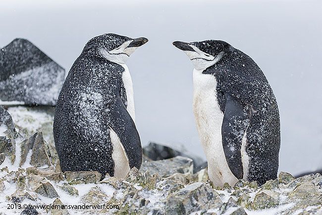
Chinstrap penguins on a sunny day at Hydrurga Rocks, Two Hummock Island. Canon EOS 1Dx, Sigma 50-500mm f/5.6-6.3 IS Lens @ 113mm, f8, 1/1600s, ISO 400, Manual exposure, hand held. Image by Clemens Vanderwerf and copyright 2013
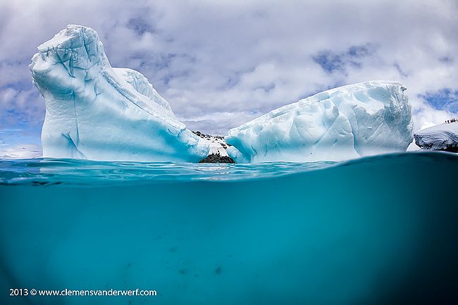
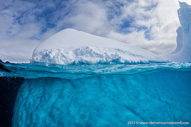
Before I went on this trip I had thought about taking images that were different. I had brought my underwater housing as a tool to accomplish this. Since the weather was sunny it would be a good opportunity to try out my vision of showing Antarctica in a different way. After collecting the underwater housing from the ship we passed by some smaller icebergs to try out if it worked. Although the exposure is somewhat of a challenge with a bright white iceberg in the sun and darker blue underwater the results were reasonable. It is very difficult to get a good composition without clipping either the iceberg above water or under water. The trick is the same as with intentionally blurred images, you have to take a lot, and hope that there are one or two nice ones.
Underwater view of iceberg at Hydrurga Rocks, Two Hummock Island. Canon EOS 5D MkII, Canon EF 15mm/f2.8 Fisheye Lens @ 15mm, f16, 1/2000s, ISO 800, Aperture Priority exposure, hand held. Image by Clemens Vanderwerf and copyright 2013
Underwater patterns of iceberg near Booth Island. Canon EOS 5D MkII, Canon EF 15mm/f2.8 Fisheye Lens @ 15mm, f16, 1/1000s, ISO 640, Aperture Priority exposure, hand held. Image by Clemens Vanderwerf and copyright 2013
Iceberg floating in Gerlache Strait. Canon 5D MkIII, Canon EF 24-70mm f/2.8L MkII USM Lens @ 35mm, f11, 1/250s, ISO 400, Manual exposure, hand held. Image by Clemens Vanderwerf and copyright 2013
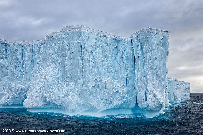
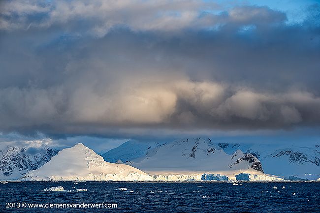
At the end of the morning the ship pulled up anchor and we passed through the Gerlache Strait in southerly direction in search for large icebergs. Once we found a nice one the captain circled around the iceberg in order to give everybody a chance the get the best possible composition. The mountain ranges along the Danco Coast are truly spectacular, and provide wide vistas of ice and glaciers often combined with beautiful cloud formations.
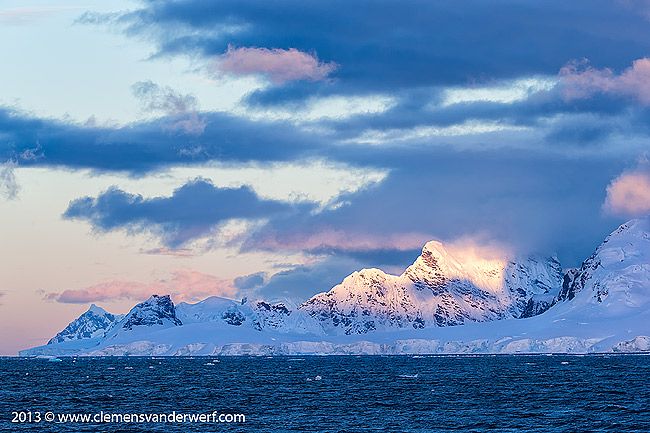
Cloud formations and last light in the Gerlache Strait. Canon EOS 1Dx, Canon EF 70-200mm f/2.8 MKII IS USM Lens @ 180mm, f6.3, 1/320s, ISO 400, Manual exposure, hand held. Image by Clemens Vanderwerf and copyright 2013
Cloud formations and last light in the Gerlache Strait. Canon EOS 1Dx, Canon EF 70-200mm f/2.8 MKII IS USMLens @ 95mm, f5.6, 1/640s, ISO 200, Manual exposure, hand held. Image by Clemens Vanderwerf and copyright 2013
During the cruise through the Gerlache Strait there was a lot of discussion if it would be possible to go through the Lemaire Channel. No other expedition vessel had been able to go through the spectacular channel due to heavy sea ice blocking the way. It was decided to give it a try and hope that the sea ice situation had changed upon our arrival. We spent the night slowly moving through Flandres Bay to get into position for the Lemaire Channel approach early in the morning.
Entrance to the Lemaire Channel in the early morning hours. Canon EOS 1Dx, Canon EF 16-35mm f/2.8L MkII USM Lens @ 16mm, f9, 1/400s, ISO 640, Manual exposure, hand held. Image by Clemens Vanderwerf and copyright 2013
First light hitting the mountains in the Lemaire Channel. Canon EOS 1Dx, Canon EF 16-35mm f/2.8L MkII USM Lens @ 16mm, f9, 1/640s, ISO 640, Manual exposure, hand held. Image by Clemens Vanderwerf and copyright 2013
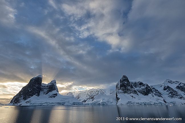
We woke up at 4 o'clock in the morning and everybody was on deck by 4:30 and dressed warm enough to be outside for a couple of hours while we approached the channel under partly overcast skies and no wind at all. The sea ice situation looked very promising as we proceeded closer. The sun peaked through the clouds and provided for some very nice lighting on the mountains. So early in the morning the scene in front of us was very blue and surreal.
Reflections of Booth Island in the Lemaire Channel. Canon EOS 1Dx, Canon EF 16-35mm f/2.8L MkII USM Lens @ 20mm, f9, 1/320s, ISO 640, Manual exposure, hand held. Image by Clemens Vanderwerf and copyright 2013
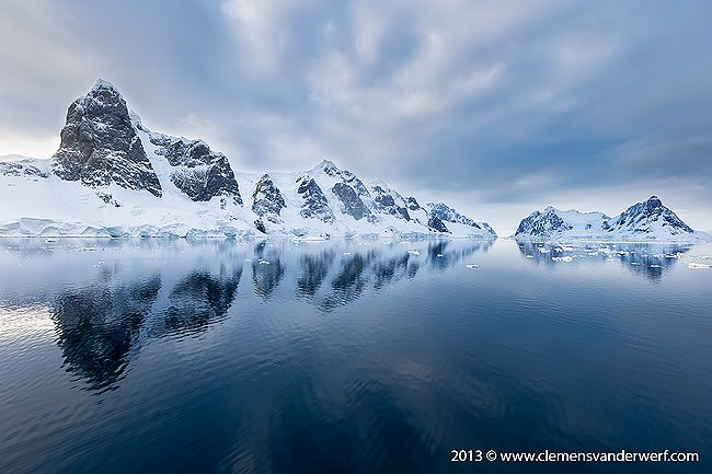
The Lemaire Channel is only 11 km long and just 1,600 metres wide at its narrowest point with steep cliffs on either side. It was first seen by the German expedition of 1873-74, but not traversed until December 1898, when the Belgica of the Belgian Antarctic Expedition passed through. Expedition leader Adrien de Gerlache named it for Charles Lemaire (1863-1925), a Belgian explorer of the Congo. The channel has become a standard part of the itinerary for cruising in Antarctica; it is not only scenic, but it also provides a protected passage towards Petermann Island. The waters are usually as still as a lake, a rare occurrence in the storm-wracked southern seas. The main difficulty is that icebergs may fill the channel, especially in early season, obliging a ship to backtrack and go around the outside of Booth Island to reach Petermann Island.
Snow stacked up on the south side of Booth Island in the Lemaire Channel. Canon EOS 1Dx, Canon EF 16-35mm f/2.8L MkII USM Lens @ 24mm, f9, 1/640s, ISO 640, Manual exposure, hand held. Image by Clemens Vanderwerf and copyright 2013
We were lucky with the ice situation as we made our way through the channel. Apparently, the Polar Pioneer was the first vessel to make it through the channel this season. When we reached the south side the plan was to go around Booth Island and visit an area where large icebergs are stranded. When we turned the corner there was a large area of closed sea ice in front of us. The captain decided to give it a try and work the ship through the ice breaking it open. This took a couple of hours as it was a very slow process of going forward, backing up and going forward again until we reached open water again.
Iceberg in iceberg graveyard near Booth Island. Canon EOS 1Dx, Canon EF 24-70mm f/2.8 MkII USM Lens @ 59mm, f11, 1/400s, ISO 200, Manual exposure, hand held. Image by Clemens Vanderwerf and copyright 2013
Sea ice on west side of Booth Island. Canon EOS 1Dx, Canon EF 16-35mm f/2.8L MkII USM Lens @ 16mm, f10, 1/400s, ISO 400, Manual exposure, hand held. Image by Clemens Vanderwerf and copyright 2013
The rest of the morning we cruised between the icebergs. The sky opened up and the sun started gaining force and before we knew it we had clear blue skies. I had brought my underwater housing with me again to give it another go. Cruising between the icebergs is a very special experience. We pulled up against one, switched off the outboard engine, and kept absolutely quite for a couple of moments. It is amazing to experience the total silence of not hearing anything, not even the smallest sound. The contrast with the world we live in every day is enormous, and that is one of the main attractions of this special place for me.
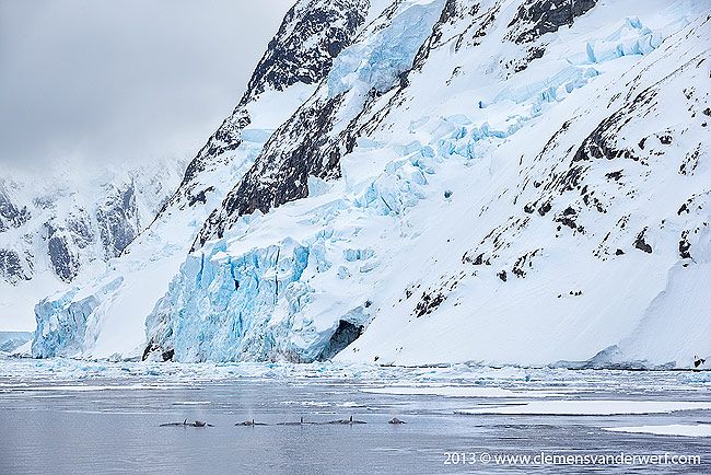
Pot of Orcas hunting near the Lemaire Channel. Canon EOS 1Dx, Sigma 50-500mm f/5.6-6.3 IS Lens @ 113mm, f8, 1/640s, ISO 640, Manual exposure, hand held. Image by Clemens Vanderwerf and copyright 2013
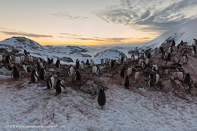
During the early afternoon we relocated to Petermann Island where we landed after dinner. The Adelie and Gentoo penguins were still busy building their nests, although some already had eggs. The large amount of snowfall in recent weeks has impacted the penguins in preparing for their breeding rituals. Penguins build their nests solely out of pebbles and small stones, and with a heavy snow pack so late in the season it makes it harder to find the right building materials. They like to set up camp on top of little rock outcrops where the snow cover is less or melted away quicker. With the mating ritual still going strong, the gathering of stones becomes a daily routine for the pairs that found their match. This seems to be a game of stealing stones from the neighbors and defending the nest materials against unwanted intruders who want to take the easy way out. Stones and pebbles are their weight worth in gold in the penguin world.
Adelie penguins stealing stones from each other, Petermann Island. Canon EOS 1Dx, Canon EF 200-400mm f/4L IS USM Lens with Internal 1.4x Extender @ 366 mm, f16, 1/800s, ISO 500, Manual exposure, hand held. Image by Clemens Vanderwerf and copyright 2013
I spent some time with a group of Adelie penguins harassing each other for the scarce building materials. It was quite funny to watch as they were picking at each other and making at lot of noise to vent their disagreement with what was going on. While it was getting later in the evening the light turned nicer and it looked like we were in for a beautiful sunset. Wandering towards the western side of the island in preparation of the sunset, I had to find a group of penguins on a ridge that would be my models for silhouettes against the colored sky. With the penguins constantly moving around you have to have a lot of patience to line up the perfect couple in a nice pose against the orange sky. This often means you have to move around yourself many times in order to get the best composition.
Gentoo penguins showing mating behavior, Petermann Island. Canon EOS 1Dx, Canon EF 24-70mm f/2.8 MkII USM Lens @ 61mm, f11, 1/320s, ISO 200, Manual exposure, hand held. Image by Clemens Vanderwerf and copyright 2013
Gentoo penguins at sunset, Petermann Island. Canon EOS 1Dx, Canon EF 24-70mm f/2.8 MkII USM Lens @ 24mm, f8, 1/80s, ISO 640, Manual exposure, hand held. Image by Clemens Vanderwerf and copyright 2013
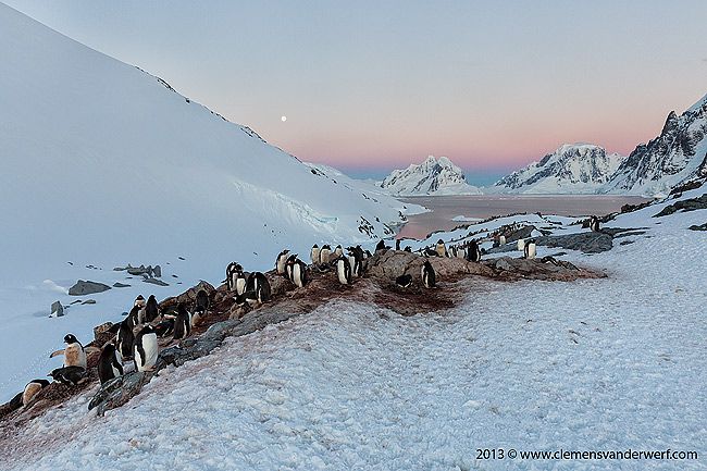
With the light getting lower the eastern sky had turned pink, purple and blue, and we were lucky to have a full moon in the sky as well. It was a beautiful scene and perfect for creating images with penguins in their natural environment with the iconic Lemaire Channel and full moon as background. By the time I went back to the ship it was well passed 11pm at night and a 20 hour day of stunning photography came to an end. The ship passed through the Lemaire Channel again at night on our way north to the next destination of Neko Harbor.
Gentoo penguins roosting for the night, Petermann Island. Canon EOS 1Dx, Canon EF 24-70mm f/2.8 MkII USM Lens @ 24mm, f10, 1/50s, ISO 800, Manual exposure, hand held. Image by Clemens Vanderwerf and copyright 2013
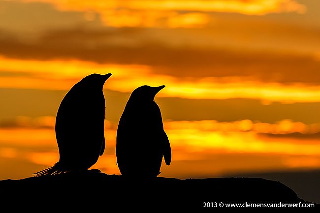
Gentoo penguins looking into the sunset, Petermann Island. Canon EOS 1Dx, Canon EF 200-400mm f/4L IS USM Lens with Internal 1.4x Extender @ 345 mm, f8, 1/640s, ISO 320, Manual exposure, hand held. Image by Clemens Vanderwerf and copyright 2013
The plan was to visit Neko Harbor in the morning and spend the afternoon in nearby beautiful Paradise Bay, but as with everything on an expedition in Antarctica, nothing is written in stone and plans change by definition always depending on the local weather circumstances. Weather is a large part of planning an itinerary in this part of the world, so flexibility is key to keep everyone happy. We arrived in Neko Harbor with heavy overcast, low hanging clouds and even a bit of snow. The ice in the bay was heavy and it was decided that instead of a landing we would do a zodiac cruise among the icebergs.
Iceberg with large underwater part and Cape Petrel, Neko Harbor. Canon EOS 1Dx, Canon EF 24-70mm f/2.8 MkII USM Lens @ 27mm, f11, 1/250s, ISO 200, Manual exposure, hand held. Image by Clemens Vanderwerf and copyright 2013
In the afternoon the plan was to relocate to Paradise bay, but word came from another vessel that due to the ice situation Paradise Bay was not accessible, which was a little bit of a disappointment because this is one of the nicest secluded bays filled with icebergs and surrounded by beautiful glaciers. Instead we relocated further north to the small island of Cuverville. The island was discovered by the Belgian Antarctic Expedition (1897–1899) under Adrien de Gerlache, who named it for J.M.A. Cavelier de Cuverville (1834–1912), a vice admiral of the French Navy. Large groups of Gentoo penguins breed on Cuverville in two large sections on either side of the landing site. The beach consists of cobbles and boulders and is usually pretty easy to access, but due to the heavy snowfall a wall of about 4 feet of snow made the access a bit more challenging. We had to dig out a couple of stairs in the snow wall in order to get everyone safely ashore.
Gentoo penguin ready for a swim, Cuverville Island. Canon EOS 1Dx, Canon EF 24-70mm f/2.8 MkII USM Lens @ 55mm, f14, 1/320s, ISO 800, Manual exposure, hand held. Image by Clemens Vanderwerf and copyright 2013
Zodiac landing at snow beach, Cuverville Island. Canon EOS 1Dx, Canon EF 24-70mm f/2.8 MkII USM Lens @ 24mm, f5, 1/100s, ISO 1000, Manual exposure, hand held. Image by Clemens Vanderwerf and copyright 2013
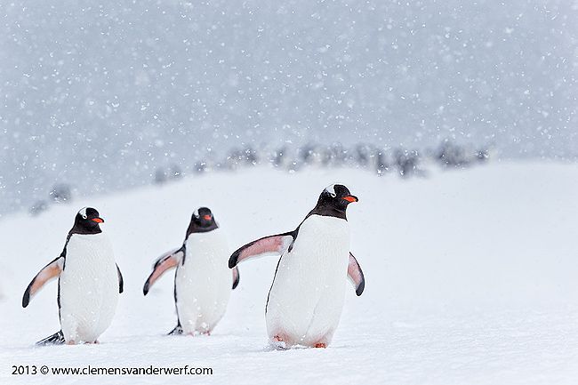
Gentoo penguins were walking in small groups from one side of the colony to the other side. It had started snowing again and thick snowflakes came down, which is great as it gives so much character to the environment, but from a photography point of view snow flakes are quite challenging as there are a whole lot of them between the camera lens and the subject. You will usually end up with some thick out of focus white spots covering the darker areas of the penguins, such as heads and wings. It helps to play around with your shutter speed to change the effect of the snowflakes. The faster the shutter speed the less white streaks you will have in the image. It also helps to take multiple images of a subject, as that increase the change that you will have an image with no or a few snowflakes covering the defining elements of the subject.
Gentoo penguins marching through the snow, Cuverville Island. Canon EOS 1Dx, Canon EF 200-400mm f/4L IS USM Lens with Internal 1.4x Extender @ 420 mm, f11, 1/800s, ISO 1600, Manual exposure, hand held. Image by Clemens Vanderwerf and copyright 2013
Gentoo penguins overlooking the bay with icebergs, Cuverville Island. Canon EOS 1Dx, Canon EF 24-70mm f/2.8 MkII USM Lens @ 24mm, f11, 1/40s, ISO 400, Manual exposure, hand held. Image by Clemens Vanderwerf and copyright 2013
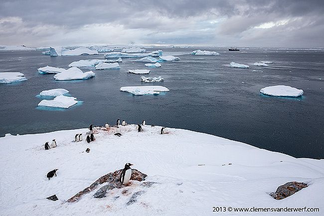
Cuverville is also a place where lots of icebergs are stranded in front of the landing site. I walked up to the top of a hill overlooking the bay for some nice scenic images, and even created some panoramas. We had to vacate the landing site by 10pm as this has been agreed under the Antarctic Treaty to allow a resting period for the wildlife until the next morning. On the way to the ship we pulled up the zodiac close to beautiful shaped iceberg that recently turned around and displayed the erosion patterns created by melting and currents.
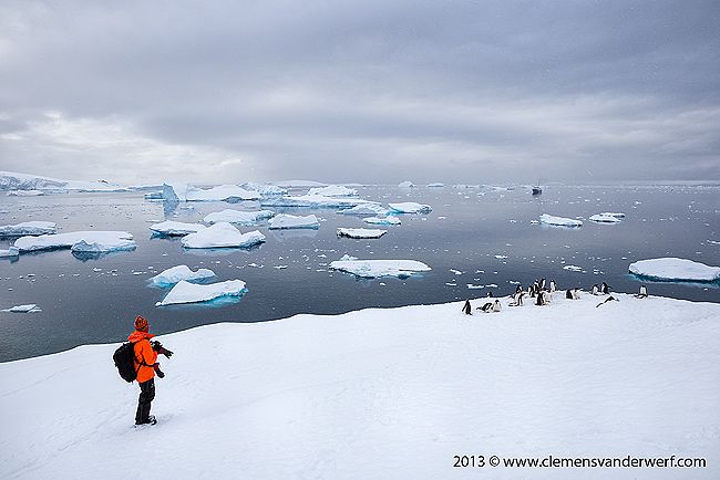
Photographer taking in the beautiful scenery, Cuverville Island. Canon EOS 1Dx, Canon EF 24-70mm f/2.8 MkII USM Lens @ 24mm, f14, 1/125s, ISO 400, Manual exposure, hand held. Image by Clemens Vanderwerf and copyright 2013
Iceberg sculpture at Cuverville Island. Canon EOS 5D MkIII, Canon EF 16-35mm f/2.8L MkII USM Lens @ 16mm, f5.6, 1/125s, ISO 1250, Manual exposure, hand held. Image by Clemens Vanderwerf and copyright 2013
The next morning we entered the Neumayer Channel on our way to Base A of the British Antarctic Survey at Port Lockroy. It was discovered in 1904 and named after Edouard Lockroy, a French politician and Vice President of the Chamber of Deputies, who assisted Jean-Baptiste Charcot in obtaining government support for his French Antarctic Expedition. The harbour was used for whaling between 1911 and 1931. During World War II the British military Operation Tabarin established the Port Lockroy base (Station A) on tiny Goudier Island in the bay, which continued to operate as a British research station until 1962. In 1996 the Port Lockroy base was renovated and is now a museum and post office operated by the United Kingdom Antarctic Heritage Trust. It is also the only place in Antarctica where you can get your passport stamped with a penguin.
Arriving at Port Lockroy, Goudier Island. Canon EOS 1Dx, Canon EF 24-70mm f/2.8 MkII USM Lens @ 24mm, f16, 1/320s, ISO 200, Manual exposure, hand held. Image by Clemens Vanderwerf and copyright 2013
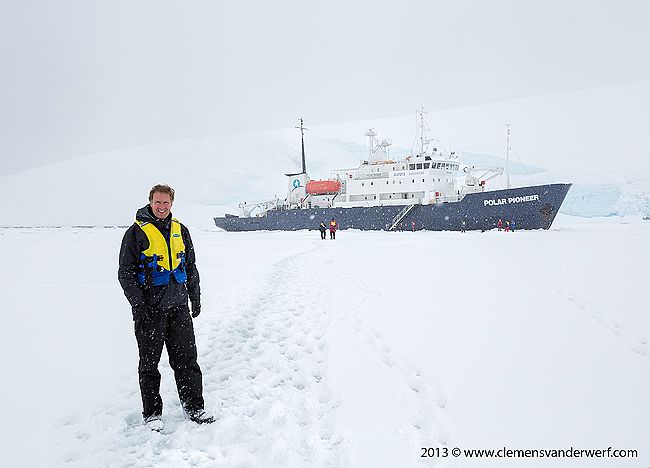
Posing in front to the Polar Pioneer in the ice, Port Lockroy, Goudier Island. Canon EOS 1Dx, Canon EF 24-70mm f/2.8 MkII USM Lens @ 35mm, f11, 1/400s, ISO 200, Manual exposure, hand held. Image by Clemens Vanderwerf and copyright 2013
As it is still early in the season the surrounding waters around the base where still frozen making a landing by boat impossible. In coordination with the staff from Port Lockroy it was decided that the captain would sail the vessel into the ice and park it there for a couple of hours. We were all on deck when the ship slowed down in the ice and came to a full stop. The gangway was lowered and three people from Port Lockroy came on board for a short briefing before we could actually walk over the ice towards the base. It was for sure a very special experience being able to step on the ice and stand next to the ship that has been our home for over a week.
Gentoo penguins displaying mating behavior, Port Lockroy, Goudier Island. Canon EOS 1Dx, Sigma 50-500mm f/5.6-6.3 IS Lens @ 373mm, f8, 1/1000s, ISO 400, Manual exposure, hand held. Image by Clemens Vanderwerf and copyright 2013
Next to Port Lockroy is a small island called Jougla Point which has a large whale skeleton. On my last trip we made a landing here and photographed the skeleton, but the difference with how it looked now was pretty amazing. You could hardly distinguish the island, let alone the beach with the skeleton, as everything was covered under a thick layer of snow. At Port Lockroy I photographed the mating behavior of the Gentoo penguins, and on the way back to the ship could not resist having my picture taken with the Polar Pioneer in the background. Little did I know that 6 weeks later the Russian sister vessel of the Polar Pioneer got stuck in the ice off the Australian side of Antarctica and made world news.
Gentoo penguin reflections, Port Lockroy, Goudier Island. Canon EOS 1Dx, Sigma 50-500mm f/5.6-6.3 IS Lens @ 138mm, f8, 1/1000s, ISO 400, Manual exposure, hand held. Image by Clemens Vanderwerf and copyright 2013
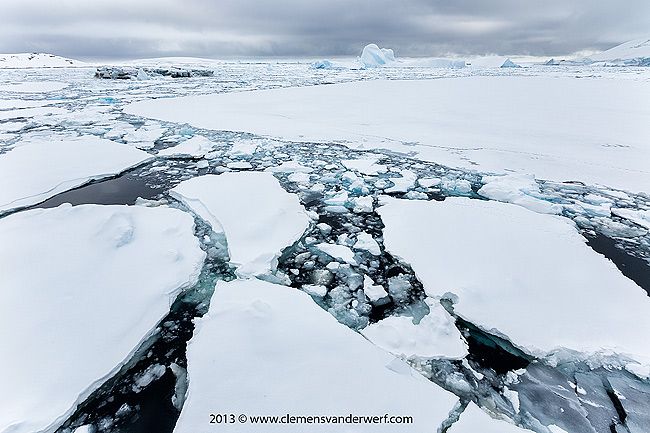
With everyone back on board the captain backed out the vessel from the ice and we proceeded towards the Neumayer Channel. The weather had turned since the early morning and strong winds had pushed a lot of sea ice into the channel, which at some point became so thick that the ship got stuck. With the persistence of the crew and a couple of hours of back and forth through the ice we made it back to the open waters of the Gerlach Strait. In my quest for a different image I used my fisheye lens to create some "world of ice" images from the bow as well as the stern of the vessel.
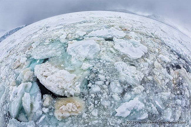
World of antarctic sea ice, Neumayer Channel, Canon EOS 5D MkIII, Canon EF 15mm/f2.8 Fisheye Lens @ 15mm, f9, 1/500s, ISO 200, Manual exposure, hand held. Image by Clemens Vanderwerf and copyright 2013
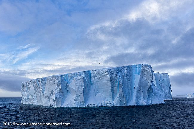
During the night we headed further north back towards the South Shetland islands for another planned landing, which by the time we arrived in the early morning was not feasible due to strong winds and heavy swell. It was decided to continue further north into the Brandsfield Strait and look for some big tabular icebergs in the Antarctic Sound. We passed a couple of really large ones that probably measure 1 to 1,5km in length. Early the next morning we approached our last landing site at Brown Bluff on the Antarctic mainland. We were on deck around 5am photographing icebergs in nice blue early morning light on the approach.
Iceberg floating en route to Brown Bluff. Canon EOS 1Dx, Canon EF 24-70mm f/2.8 MkII USM Lens @ 30mm, f11, 1/200s, ISO 400, Manual exposure, hand held. Image by Clemens Vanderwerf and copyright 2013
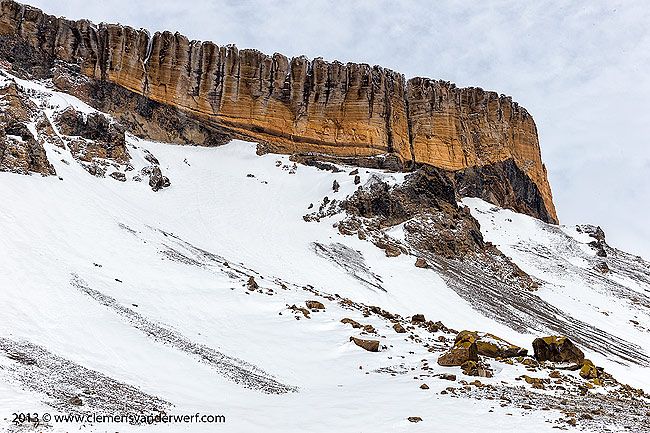
Brown Bluff is an ice-capped, flat-topped 745m extinct volcano. The original diameter of the volcano has been calculated at 12 to 15 km, and is approximately one million years old. The bluff takes its name from a striking cliff of reddish-brown rock on its north face. By the time we had anchored off Brown Bluff the wind had picked up and made the ride over to the shore a cold and wet one. The beach was scattered with large ice cubs that had been rolling up and down in the surf. Adelie penguins were carefully making their way over the ice cubs to reach the water and were debating if it was worth to take the plunge.
Vulcano rim at Brown Bluff. Canon EOS 1Dx, Canon EF 24-70mm f/2.8 MkII USM Lens @ 47mm, f16, 1/500s, ISO 400, Manual exposure, hand held. Image by Clemens Vanderwerf and copyright 2013
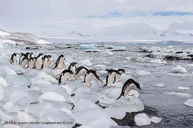
Adelie penguins on their way to water edge, Brown Bluff. Canon EOS 1Dx, Sigma 50-500mm f/5.6-6.3 IS Lens @ 50mm, f13, 1/800s, ISO 400, Manual exposure, hand held. Image by Clemens Vanderwerf and copyright 2013
The wind had picked up further and the landing had to be abandoned because the swell at the ship was getting larger and reached the point were it would be difficult to get everybody back on board. Unfortunately, that left no time to cruise around the icebergs with Adelie penguins on them, as we had to go straight back to the ship.
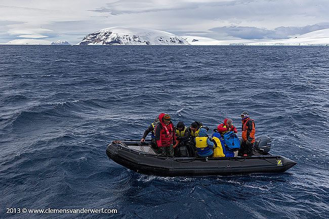
Passengers getting back to the ship in zodiac, Brown Bluff. Canon EOS 1Dx, Canon EF 24-70mm f/2.8 MkII USM Lens @ 38mm, f16, 1/640s, ISO 400, Manual exposure, hand held. Image by Clemens Vanderwerf and copyright 2013
One last landing was planned on Elephant Island before we would hit the southern ocean again on our way to the Falkland Islands where we would end the expedition. Elephant Island is an ice-covered mountainous island off the coast of Antarctica in the outer reaches of the South Shetland Islands. Its name was given by early explorers sighting elephant seals on its shores. The island is most famous as the desolate refuge of Ernest Shackleton and his crew in 1916. Following the loss of their ship Endurance in Weddell Sea ice, the 28 exhausted men reached Elephant Island after a harrowing ordeal on drifting ice floes. They established a camp at a place they called Point Wild where they were able to regain some strength. Realizing that there was no chance of rescue, Shackleton decided to sail to South Georgia where he knew there was a whaling station. In one of the most incredible feats in the history of sailing and navigation, Shackleton sailed with five other men on an 800-mile (1,287 km) voyage in the open lifeboat James Caird on Easter Monday, April 24, 1916, arriving at South Georgia almost two weeks later. His second-in-command, Frank Wild, was left in charge of the men on Elephant Island, waiting for Shackleton's return with a rescue ship.
Luck was not on our side when we arrived in the early morning at Elephant Island. The wind was close to 35 knots and the swell prevented a safe landing ashore. It was decided that we had to do with a sail by of Point Wild, and had to imagine the bare living circumstances the Shackleton crew had to endure from behind the ship's windows. I can tell you that it did not look very luxurious at all.
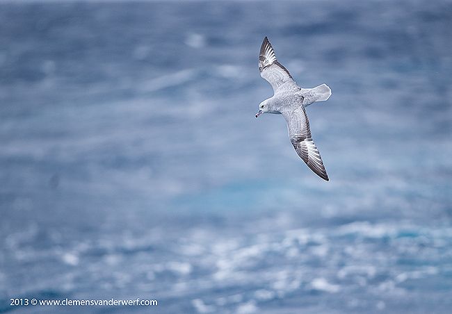
Southern fulmar riding the waves, Southern Ocean. Canon EOS 1Dx, Canon EF 200-400mm f/4L IS USM Lens with Internal 1.4x Extender @ 560 mm, f5.6, 1/1600s, ISO 800, Manual exposure, hand held. Image by Clemens Vanderwerf and copyright 2013
The weather forecast was not looking too good for our crossing towards the Falklands. One of the other vessels that was on its way from the Peninsula back to Ushuaia was having 55 knots of wind in the Drake Passage. We all had to make sure that our equipment was stored safely and that sea-sickness prevention was applied for those who needed it. It was going to be a rough two days at sea.
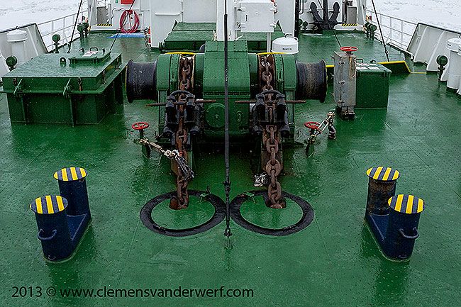
Anchor securing was not properly attached to the anchor chain. Canon EOS 5D MkII, Canon EF 15mm/f2.8 Fisheye Lens @ 15mm, f11, 1/400s, ISO 200, Aperture Priority exposure, hand held. Image by Clemens Vanderwerf and copyright 2013
We were pitching and rolling along during the afternoon of the first day at sea when all of a sudden we heard a terrible sound coming from the bow. It took a while to realize that the starboard anchor had left it's secure place against the bow of the vessel, and was now hanging about 200 meter below the surface. A large wave had hit the anchor and loosened the brake on the anchor winch, and all the anchor chain had gone down with the anchor. Apparently, the extra lock that secures the chain was not properly attached (see image above) by the crew or had given way under the slamming force of the wave. The vessel had stopped and the captain kept the bow in the wind as good as possible. The deck crew was busy with the task of getting the anchor and chain back on board again. This was no easy task as the anchor winch could not pull the full weight of the anchor and all the chain without overheating. One of the mooring lines was hooked up to anchor chain, and with the help of the mooring winch at the stern of the vessel the chain was pull in meter by meter, every time disconnecting the mooring line from the chain and reconnect it again at a lower point. The whole operation took at least 6 hours before enough chain was back on board and the total weight was reduced enough to let the anchor winch take over without overheating.
Light mantled sooty albatross banking above waves, Southern Ocean. Canon EOS 1Dx, Canon EF 200-400mm f/4L IS USM Lens with Internal 1.4x Extender @ 560 mm, f5.6, 1/2000s, ISO 400, Manual exposure, hand held. Image by Clemens Vanderwerf and copyright 2013
We continued our voyage without any further incidents and the weather slowly improved when we got closer to the Falklands. There were even some good opportunities to photograph a variety of birds off the back of the ship. The vessel entered Port Stanley on the Falklands in the early morning, in time to catch the only commercial flight from the Falklands to Punta Arenas in Chile.
It was great to experience the Antarctic continent again, and see the differences in scenery and wildlife compared to my previous voyage. Although I have been privileged to visit Antarctica for a second time, there is so much more to see and to experience that I will go back again. I can only hope that we, as global citizens, will take good care of this special place, as it plays such an important part for our future existence on this planet as we became to know it.
More images of my November Antarctica 2013 experience are on my website at www.clemensvanderwerf.com